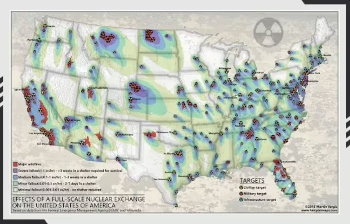
Nuclear targeting maps based on FEMA data reveal harsh geographic truths about survival odds across America. Western Texas, most of Nevada, Michigan, and Wisconsin emerge as relatively safer zones — not because they’re immune to attack, but because they sit farther from high-value military targets.
The logic is coldly strategic. Major cities like New York, Chicago, Houston, Los Angeles, and San Francisco top target lists alongside critical infrastructure. Meanwhile, Midwest states housing ICBM silos — North Dakota, Wyoming, and Montana — face the highest immediate risks due to their strategic military installations.
Alex Wellerstein’s NUKEMAP simulation tool, used over 275 million times, demonstrates why distance matters. Recent usage spikes tied to Ukraine war tensions show Americans increasingly modeling blast radii, casualties, and thermal effects for their own regions.
The Brutal Math of Fallout
Even “safe” states face contamination, nuclear winter, and infrastructure collapse.
Here’s where the maps become meaningless. Experts emphasize that no U.S. location offers genuine safety from nuclear war’s cascading effects.
Widespread fallout contaminates food and water supplies regardless of proximity to blast sites. Nuclear winter could render even Michigan and Wisconsin uninhabitable despite avoiding direct hits.
The Red Cross recommends sheltering for 24 hours to one month post-attack — guidance that applies everywhere, not just target zones. NUKEMAP simulations show even historically massive weapons like the Tsar Bomb detonating over Indianapolis would cause regional casualties spanning multiple states.
Areas near missile silos or coasts face the highest immediate risks, but fallout patterns don’t respect state boundaries. Radioactive contamination follows wind patterns and weather systems, potentially affecting regions hundreds of miles from blast sites.
These sobering realities explain why survival preparedness focuses on immediate response rather than relocation strategies. While Western Texas might avoid direct targeting, post-attack America would face supply chain collapse, mass displacement, and environmental devastation that renders geographic advantages largely irrelevant.
The maps serve as planning tools, not escape routes.